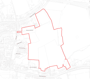
Potential Development – Land South of Fillongley Road and Behind Main Road
A representative from Marrons attended the Parish Council meeting last night (17 November 2025) and briefly spoke in the public forum of a potential development of approximately 200 dwellings with public open space – see map below. At this stage, the Parish Council has no other information and Marrons stated that they will be promoting the land for development in the coming months.
Marrons confirmed any potential development in this area would NOT include the allotments shown on the map.
Many areas within Solihull are now being promoted for development due to the Govt. reclassification of green belt (introduction of grey belt) and SMBC needing to find additional housing.
Marrons will be creating concept designs and will undertake a consultation with the Parish before an application is submitted to Solihull Council planning. SMBC would also need to assess this application for suitability and consult their revised green belt assessment, which should be published in December 2025.
The only information received by the Parish Council to date is the map below. As soon as the Parish Council receives any information on a concept design or consultation it will be shared with residents.